Official Name:
Ю§ІЛ№өіӨіЗ4¶ОCaiGouChangCheng4DuanOur Name:
/
Other Name:
/
Period:Гч / Ming Dynasty 1368~1644
Location: іҜСфКР,ұұЖұКР,ЖрөгЈәіЈәУУӘПзАПТҜГнҙеЮ§ІЛ№ө(ОчЙҪОчДП1400ГЧёЯЙҪЙП)Ц№өгЈәіЈәУУӘПзАПТҜГнҙеЮ§ІЛ№ө(ОчЙҪОчДП1700ГЧёЯЙҪЙП) / ChaoYangShi,BeiPiaoShi,QiDianChangHeYingXiangLaoYeMiaoCunCaiGou(XiShanXiNan1400MiGaoShanShang)ZhiDianChangHeYingXiangLaoYeMiaoCunCaiGou(XiShanXiNan1700MiGaoShanShang)
ЎЎ[
Looking Local List]
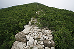
Details:іӨіЗАаұрЈәЗҪМе
ЖрөгҫӯОіёЯ¶ИЈә¶«ҫӯЈә121Ўг 9Ўд ұұОіЈә41Ўг 40Ўд әЈ°ОЈә471
ЦХөгҫӯОіёЯ¶ИЈә¶«ҫӯЈә121Ўг 9Ўд ұұОіЈә41Ўг 40Ўд әЈ°ОЈә387
ЗҪМеЧЯПтЈәЗҪМеҙуМеіК¶«ДП-ОчұұЧЯПтЎЈёГ¶ОіӨіЗКҜЗҪЖрЧФі
ЗҪМеАаұрЈәКҜЗҪ
Ҫб№№МШөгј°№№Цю·ҪКҪЈәЖКГжіКМЭРОЎЈёГ¶ОЦчЗҪМе»щҙЎОӘЧФИ»ЙҪМеСТКҜ»щҙЎЈ¬ЗҪЙнУГКҜҝйАЭЦюЈ¬ЗҪМеПтЙПКХ·ЦІ»ГчПФЈ¬ЖКГжОӘМЭРОЈ¬ЗҪЙнУГҙуҝйЙҪКҜёЙАЭЈ¬ЗҪМеЙиК©ОЮҙжЈ¬ЗҪҝн1.5ГЧЎ«2.2ГЧЈ¬ПЦҙжёЯ¶И1ГЧЎ«1.5ГЧЎЈ
ПЦЧҙЈәёГЗҪМеОӘКҜЗҪЎЈКҜЦКТФ№иСТОӘЦчЈ¬ЦКөШјбУІЎЈ
Type:КҜЗҪ Stone wall
Protection Level:ОЮ
ЎЎ
Content:
Memo:
Other Records:
Distribution:
visit location in Tianditu Map[recommend] Distribution:
visit location in Tencent QQ Map Distribution:
visit location in Google MapDistribution:
visit location in Baidu MapNational ID:211381382102170009
Action:[
 Save in Data Basket
 ]
Picture:
Click the thumbnail to view the Big Pic. Click the Big Pic to Hide the Big Pic![Caption:Ю§ІЛ№өіӨіЗ4¶О
loading images --Please wait...]()
![Caption:Ю§ІЛ№өіӨіЗ4¶О
loading images --Please wait...]() Photo Links
Photo Links:
ЎЎ Search ::
  Favorite/My Favorite :: Recent Changes :: :: Login